Atlas InSAR monitoring studies provide regular and flexible updates on ground and asset motion throughout the construction, operation, and maintenance phases of any site or project.
The frequency of measurements can be tailored to project stage requirements and adjusted based on the criticality of each phase — weekly, fortnightly, monthly, quarterly, or yearly.
Atlas InSAR offers customized services, from rapid bulletins that provide a quick overview of the latest measurements to comprehensive reports, with detailed analyses of every critical area/asset on the project.
Atlas InSAR is a robust, efficient and cost-effective monitoring solution to minimise and mitigate geotechnical risks.
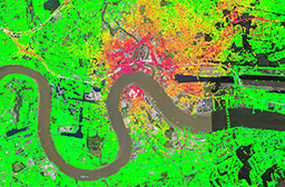
Continuous ground deformation monitoring from space
Our Atlas InSAR advanced processing chain is designed to work with any type of satellite radar (SAR) images.
Sixense teams can task SAR satellites to acquire images over any site every few days, enabling the development of customized monitoring programs that provide ground and asset motion information and support clients in managing different project situations.
Different satellites will be tasked depending on site and motion characteristics. Atlas InSAR can work with X-, C- or L-band sensors to ensure the most reliable information is obtained for each project.
New constellations are being launched and very soon daily imagery will be available for real-time satellite monitoring programmes at a fraction of the cost of traditional monitoring.
Monitor the impact of construction works
Atlas InSAR monitoring can be applied during the construction phase of any project, providing millions of measurement points with millimetric precision.
The area covered by InSAR analyses can extend beyond the defined Zone of Influence (ZOI), making it a valuable tool for detecting deformations that exceed the expected perimeter, such as those resulting from dewatering activities. This makes Atlas InSAR an ideal solution for addressing subsidence claims and complementing in-situ instrumentation.
Monitor tunneling activities: ground settlement due to volume loss
Atlas InSAR monitoring is particularly suited to monitor ground surface displacement resulting from tunneling activities and to measure its impact on existing buildings and infrastructures.
During tunnelling advancement, InSAR Atlas monitoring solutions are used to monitor ground settlement due to volume loss, verify surveying reference points and map any widening of the settlement outside the calculated ZOI.
Risk reduction in mining and tailings dams
Atlas InSAR Monitoring enables customized monitoring programs to support mining activities.
It can track ground motion at both underground and open-pit mining sites and can be used to ensure the stability of critical infrastructures, including tailings dams, waste dumps, access roads, and pipielines.
By providing regular, high-precision measurements, Atlas InSAR helps mining operators identify potential risks early, optimize safety measures, and reduce operational and environmental impacts.
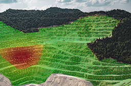
Early warning tool: detect precursor motion to landslide and slope failures
Atlas InSAR monitoring is an effective tool for detecting precursor movements leading to landslides or slope failures across large areas, such as highways, railways, and pipelines, as well as in remote or critical infrastructure, including mines, tailings dams, and bridges.
Non-linear movements or acceleration in motion can be identified, enabling the implementation of early-stage mitigation measures to reduce risks and enhance safety.
Long-term maintenance
Atlas InSAR Monitoring is the perfect tool to design long term maintenance programmes.
It provides cost effective measurements and wide area coverage to assess structural health and detect displacement likely to cause damages to infrastructure.
The additional benefits of using our Atlas InSAR solution
A unique competence combining InSAR data and Ground Instrumentation data
• Integrated ground and space sensor monitoring solutions
• Applicable to many industries
• More than 800 engineers dedicated to construction
• 10+ years of radar data processing expertise
Atlas InSAR - a high quality processing chain
• In-house InSAR solution developed in 2004
• Constantly evolving
• Compatible with all satellite sensors
• Adapts to new SAR data volumes
• Ready for next-generation missions
Beyond Monitoring - advanced web-GIS platform
• Actionable InSAR data
• User-friendly and intuitive
• Customised insights
• Advanced analytics and filtering tools
• Multi-sensor integration
• Holistic asset control
Download the Atlas InSAR solution datasheet