Radar satellites have been collecting images of the earth surface since 1992.
These images can be accessed and the data processed to map and measure ground and infrastucture motion from the past.
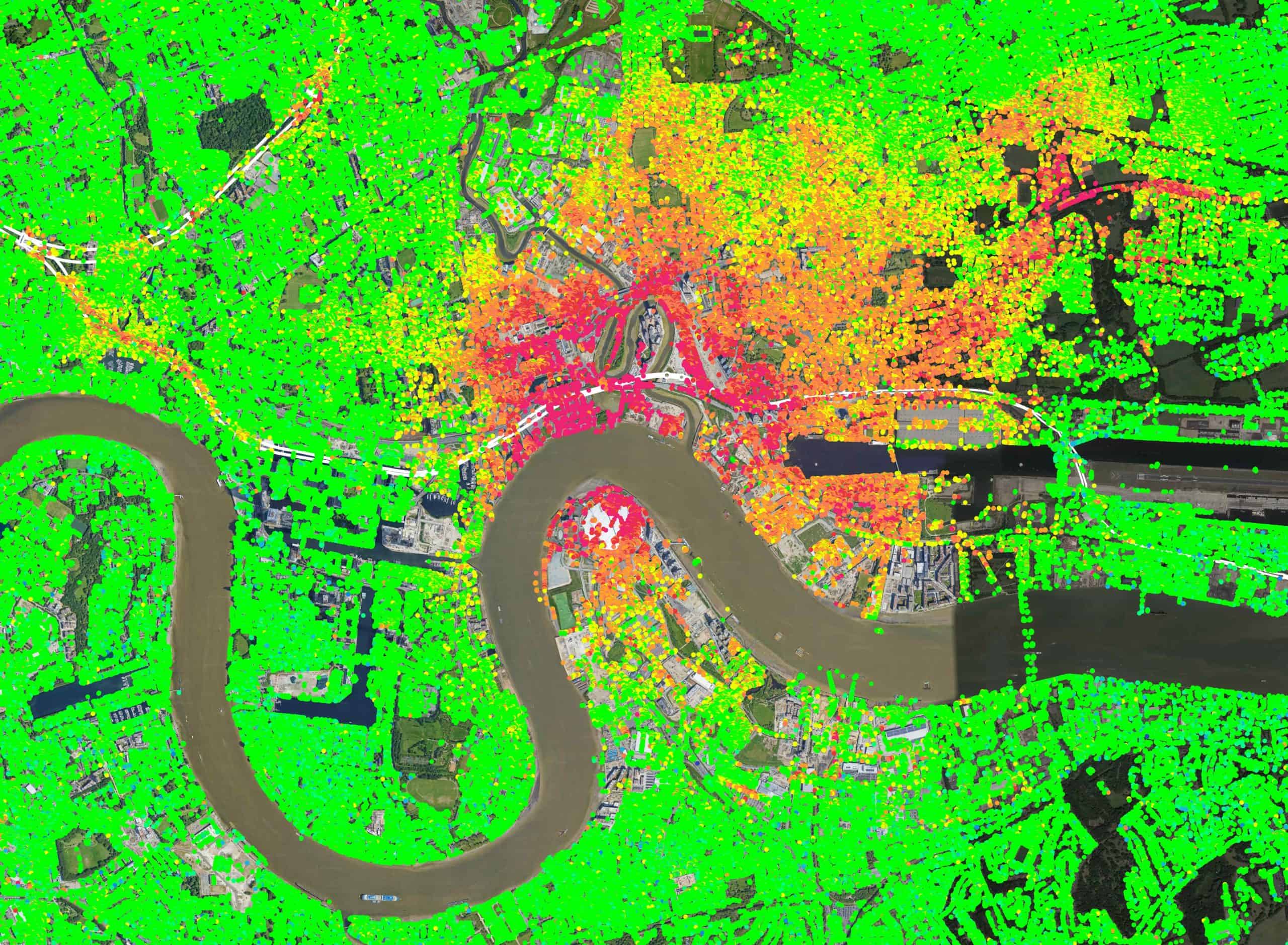
Atlas InSAR technology can look back in time to show where the ground has moved and by how much, across all areas covered by satellite images.
Measuring ground motion from space
30 years of satellite data with Atlas InSAR
Space agencies (ESA, JAXA, NASA, among others) launched satellites with SAR sensors as early as 1990. Those satellites actively acquired images worldwide. Today, Sixense can download and process those images to precisely map and understand past ground and asset behavior, enabling stakeholders to make informed decisions.
Since last decade, available archives of High-Resolution satellite imagery in major cities allow measuring deformation in urban areas with high precision and detail.
These retrospective studies are particularly suitable for projects under design phase, helping engineers to anticipate risks and identify vulnerable spots, for forensic analyses to understand past events, and for litigation protection by supplying solid, independent proof.
Understanding terrain behaviour for project planning and design
During the planning and design phase of any type of infrastructure, Atlas historical studies provide a retrospective mapping of deformations affecting the future construction site and a precise analysis of terrain dynamic evolution in time.
Atlas is a valuable tool for site selection and characterisation before work begins.
Inventory of critical spots
Thanks to the large coverage of radar satellite images, Atlas InSAR solution is particularly well-suited to perform inventories of critical spots affecting, for example, large linear infrastructures spanning several hundred kilometers, such as railways, highways, or pipelines.
Natural subsidence or heave, active slopes, and areas prone to landslides can be easily identified along infrastructures, allowing timely implementation of mitigative actions.
Risk analysis, sustainability and urban planning
Atlas InSAR historical studies can be performed at a regional scale anywhere in the world and are often applied to large cities and municipalities.
In such cases, Atlas becomes a strategic tool for local authorities and land developers to identify zones at risk or experiencing vulnerabilities that may impact urban growth.
Typical situations include subsidence caused by aquifer overexploitation, areas of sediment compaction, coastal erosion, flood-prone zones that may threaten infrastructure integrity and community safety, among others.
Atlas InSAR contributes to the implementation of strategic and sustainable territory development plans.
Optimisation and implementation of an efficient instrumentation plan
Atlas InSAR historical studies can be used to identify pre-existing ground deformations before construction works begin, thus allowing the optimization of traditional instrumentation programs with real-time or manual sensors.
Atlas InSAR, combined with Sixense’s expertise in ground instrumentation, assure the implementation of a cost-efficient ground sensor network and the design of tailored solutions for each project.
Protecting projects from legal claims
Atlas InSAR historical studies make it possible to generate a map of past ground motion beyond the zone of influence (ZoI) and to identify infrastructures and buildings already affected by deformation before the start of construction works.
In many countries over the past few years, Atlas InSAR has proven to be an effective tool against claims, providing clear and unambiguous evidence in legal disputes.
Sixense teams assist claims managers in leveraging InSAR data effectively.
The additional benefits of using our Atlas InSAR solution
A unique competence combining InSAR data and Ground Instrumentation data
• Integrated ground and space sensor monitoring solutions
• Applicable to many industries
• More than 800 engineers dedicated to construction
• 10+ years of radar data processing expertise
Atlas InSAR - a high quality processing chain
• In-house InSAR solution developed in 2004
• Constantly evolving
• Compatible with all satellite sensors
• Adapts to new SAR data volumes
• Ready for next-generation missions
Beyond Monitoring - advanced web-GIS platform
• Actionable InSAR data
• User-friendly and intuitive
• Customised insights
• Advanced analytics and filtering tools
• Multi-sensor integration
• Holistic asset control
Download the Atlas InSAR solution datasheet