Skip to content Transforming your infrastructure into living assets

Geotechnical monitoring

Monitoring movement in soil and earthworks structures

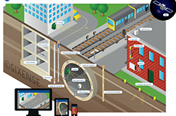
Total safety for earthworks, excavations, foundations and operations

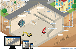
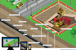
The construction of earthworks, specialist foundations, tunnels and other subsurface structures inevitably generates ground movements that may require monitoring. Using geotechnical sensors to carry out this task provides control of geotechnical risks, and can contribute input to the process of optimising the dimensioning of subsurface structures.
Sensors installed during the earthworks project can be retained for long-term monitoring of cuttings and embankments, for example.

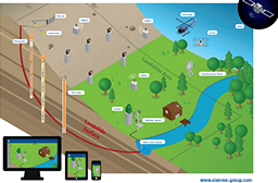
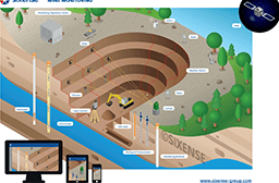
Geotechnical sensors can also be used to monitor soil movements such as landslips, settlement, etc. The data the instruments provide helps engineers and consultants understand and diagnose the cause of the failure, and in turn this helps remedial solutions to be designed and deployed on site to arrest or manage future movements.

Installed on the surface or below ground, geotechnical sensors can be used to measure:

  • Soil water levels
  • Ground deformations: settlements, heave and slip
  • Stress states, etc.

Installing geotechnical sensors allows you to:

  • Control the geotechnical risks associated with your special foundation works and subsurface structures
  • Understand soil behaviour as the basis for:
    • Checking actual deformations versus theoretical sizing
    • Optimising the sizing of underground structures
    • Managing geotechnical risks (e.g. landslips)
    • Monitoring changes in the structural soil state over the long term (in embankments and cuttings, etc.)

Deformation and strain measurements

Ground deformation sensors

  • Borehole extensometers provide millimetric measurements of relative displacement between anchor positions along the axis of the instrument’s installation. They can be installed vertically, horizontally, inclined and in some cases, inverted. Borehole settlement gauges provide a less accurate, but also less expensive, version for use with larger scales of deformation
  • Inclinometers measure the lateral deformation of the ground with millimetric accuracy when installed vertically. They can be installed directly in the soil or in foundations (diaphragm walls, piles, etc.). They can also be installed horizontally to record settlement profiles.
  • A number of instruments are available for measuring settlement in embankments, and are often referred to collectively as embankment settlement meters
Sensors that can be sued to determine soil stress state include Earth Pressure Cells.

Measurement of sub-surface water levels and pore pressures

Sensors to measure sub-surface water levels (piezometric sensors) and interstitial pressure (Interstitial Pressure Cells or IPCs)

  • Inexpensive and easy to manufacture, piezometers can be read manually or automatically using a variety of datalogging solutions
  • Interstitial Pressure Cells (IPCs) provide crucial information on soil behaviour at predefined depths

Cyclops

Automated 3D topographic monitoring of structures and surfaces

Cyclops™ is Sixense’s world leading automated topographic measurement solution and provides:

  • remote, automatic, 3D movement measurement with sub-millimetric accuracy
  • the possibility to group theodolites within globally unstable areas to deliver improved reading stability and repeatability

Find out more about our Cyclops solution

4DBloc

GNSS-based deformation sensor

4DBloc is a GNSS sensor for real-time monitoring of ground or structure deformations.

The 4DBloc system provides:

  • an accurate and robust monitoring solution that can be deployed in a variety of scenarios to record the movement of soil and structures
  • real-time movement monitoring (with improved resolution using aggregated data)

Find out more about our 4DBloc sensor

4DSkin

Synthetic aperture radar

Our 4DSkin solution enables non-contact deformation measurements to be made over large areas of up to several kilometres, at high frequency (typically every 2 minutes) and to a very high level of accuracy (typically 0.2 mm).

Find out more about our 4DSkin sensor

4DShape

3D continuous linear inclinometer

4DShape is an all-in-one solution that uses a flexible chain of 3D inclinometers to monitor the relative movement of vertical, horizontal or converging profiles in soils and on structures.

Find our more about our 4DShape solution

The added benefits of using our geotechnical monitoring

Cutting-edge expertise

from a programme of continuous development over nearly three decades of experience and in-house development in the construction industry

The availability of dedicated local teams

by utilising an extensive global network of experienced and qualified technicians, engineers, project managers and data engineers

A turnkey service

from technical guidance at project inception to management of processed data during, and even beyond the construction phase

A culture of innovation

A commitment to continual development and improvement of solutions more closely aligned with the practical challenges of our clients

A proactive maintenance programme

delivered to ensure optimal data quality as part of our commitment to providing accurate and reliable monitoring information